1779 Map and Survey |
| Back | Map Index | Village Centre | Long Street | Tathall End | Main Map |
Henry Lowndes is recorded as an owner of property in Hanslope parish in the 1779 survey.
| Owner | Ref.No. | Description | Building link | View Map Index |
| Henry Lowndes | 737 | Long Pightle with tenement and garden | none | |
| 738 | A small close called Hundred Acres | none | ||
| 742 | A capital farm house, outbuildings, yard, orchard, garden pools and pightles | 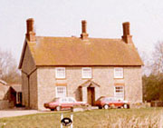 Ivy Farm |
||
| 783 | A farm house, outbuildings, yard and garden | none | ||
| 784 | Two tenement buildings and gardens | none | ||
| 792 | Tenement and garden | none | ||
| 821 | Farm house, outbuildings, yard, garden, orchard and close | 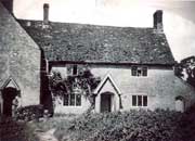 39-42 Tathall End |
|
Notes:
To view the page or index from the Survey referring to an entry above,
click on the For further information about buildings referred to, click on the building link. To locate the properties on the map, select either the
full map of the parish, or one of the extracts showing |
| Back | Home Page | Map Index | Village Centre | Long Street | Tathall End | Main Map |