| 1818 Map and Survey Background |

|
| The map and accompanying survey document are held as part of the Watts family archive at the Centre for Buckinghamshire Studies in Aylesbury.
The Map
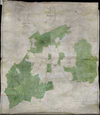 The map covers the whole parish of Hanslope. It measures approximately 6 feet by 6 feet and seems to have been intended to hang on a wall. It was drawn on parchment (made from sheep skin) mounted on linen, and was prepared by John King. The map covers the whole parish of Hanslope. It measures approximately 6 feet by 6 feet and seems to have been intended to hang on a wall. It was drawn on parchment (made from sheep skin) mounted on linen, and was prepared by John King.
The map shows every house and field in the Parish. Colour coding is used on the map as follows: areas owned by Edward Watts are shaded green, properties not owned by Edward Watts are drawn grey. All buildings are coloured red regardless of ownership.
Measures of area on the map are in acres, roods and perch: 1 acre = 4 rood = 160 perch (1 rood = 40 perch). One acre is approximately 4,047 square meters.
|
|
The Accompanying Survey
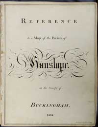 A separate survey volume provides descriptions and additional information on houses and land. A separate survey volume provides descriptions and additional information on houses and land.
 The early pages list farms owned by Edward Watts, including every field, homestead and cottage, using the same numbering system as on the map. Maps of several farms are provided. There are also pages on the letting of houses in Hanslope village and Tathall End. The early pages list farms owned by Edward Watts, including every field, homestead and cottage, using the same numbering system as on the map. Maps of several farms are provided. There are also pages on the letting of houses in Hanslope village and Tathall End.
Further pages list property (houses and land) in the parish owned by others.
The last 7 pages provide a summary by owner of land in the Parish.
|
|
Presentation on this Web site
The map is available on a page that provides zoom and pan features using Google map functions to allow the full detail of the map to be explored. Also available on separate pages are sections cut out from the map for the Village Centre, Long Street and Tathall End.
The survey report can be paged through, including the separate maps for each farm. An index has been prepared to facilitates direct access to a specific page.
An index page provides an alphabetical lists of people (owners and tenants) mentioned, and an index of houses using reference numbers from the map and survey. These indexes provide links to further information about building on the web site.
All persons mentioned in the survey are include in the index of Hanslope people. Links to the survey will appear in results of searches for the people in the family history section.
|
|
| map thumbnails & links here |
|
|
|
Copyright
The original map and survey are held by the Centre for Buckinghamshire Studies, County Hall, Aylesbury, Bucks HP20 1UU, UK, which administers copyright (document references: map D/WA/157.R, survey D/WA/156). Copies may be made for private use, but anyone wishing to publish the map or survey, in whole or in part, or to reproduce them on their web site should contact the Centre for permission to do so.
|
|