1779 Map and Survey |
| Back | Map Index | Village Centre | Long Street | Tathall End | Main Map |
John Gurney is recorded as both an owner and a tenant of properties in Hanslope parish in the 1779 survey, as summarised in the following.
| Owner | Ref.No. | Description | Building link | View Map Index |
| John Gurney | 645 | A tenement and garden at Church-end purchased of William Kitlee | 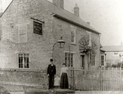 Black Bull, Gold Street |
|
| 735 | Part of Long Pightle and building thereo | none |
| Tenant | Ref. No. | Description | Building link | View Survey Page |
| John Gurney | 207 | The Royal Oak homestead and garden | 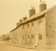 Coronet or Coronation Cottages |
|
| John Gurney | 209 | A tenement and garden | 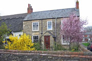 51 High Street |
|
| John Gurney | 209 | A tenement and garden | 51 High Street |
|
|
Notes:
To view the page or index from the Survey referring to an entry above,
click on the For further information about buildings referred to, click on the building link. To locate the properties on the map, select either the
full map of the parish, or one of the extracts showing |
| Back | Home Page | Map Index | Village Centre | Long Street | Tathall End | Main Map |