1779 Map and Survey |
| Back | Map Index | Village Centre | Long Street | Tathall End | Main Map |
William Crick is recorded as a tenant of property in Hanslope parish in the 1779 survey, including the following houses and cottages.
| Tenant | Ref. No. | Description | Building link | View Survey Page |
| William Crick | 77 | A farm house, outbuildings, rickyard and garden | 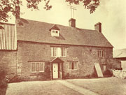 Farm House, Model Farm, 73 Long Street |
|
| William Crick | 81 | A house, yard and garden, late James Fretter tenant | 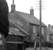 51 Long Street |
|
| William Crick | 166 | A tenerment and garden | none | |
| William Crick | 167 | A tenerment and garden |  Old Pest House |
|
Notes:
To view the page or index from the Survey referring to an entry above,
click on the For further information about buildings referred to, click on the building link. To locate the properties on the map, select either the
full map of the parish, or one of the extracts showing |
| Back | Home Page | Map Index | Village Centre | Long Street | Tathall End | Main Map |